WHITESTONE 1. 2. AND 3
Miles of Cable Corridors, the Loss of Valleys, and a Connection to Nowhere
Across South Yorkshire a familiar pattern is emerging. Solar developers announce that they have “reduced” their schemes after listening to local concerns. Press releases talk about removing panels near homes, creating buffers, or improving biodiversity.
It sounds reassuring.
But look closely at the planning documents and something very different emerges.
The projects may shrink on paper, but the overall land take remains vast, the cable corridors grow wider, and the grid connections often remain uncertain or entirely dependent on infrastructure that does not yet exist.
Whitestone Solar Farm provides a perfect example of how this works.
The Illusion of Reduction
Developers claim they have reduced the “developable area” of Whitestone by removing sections of solar panels. On the surface, this sounds like a concession to local residents and the countryside.
But the key phrase here is developable area.
Many of the areas supposedly removed from solar development are still included within the project boundary. They are simply redesignated as:
ecological mitigation land
landscape buffers
access corridors
cable routes
In other words, the land is still inside the red line of the project.
This distinction matters enormously.
Planning applications are not determined on marketing language but on the full Order limits — the maximum land area that could be developed during construction and operation.
So while panels may shift slightly within the site, the countryside remains effectively absorbed into the scheme.
For residents and farmers, the reality does not change.
The landscape is still transformed.
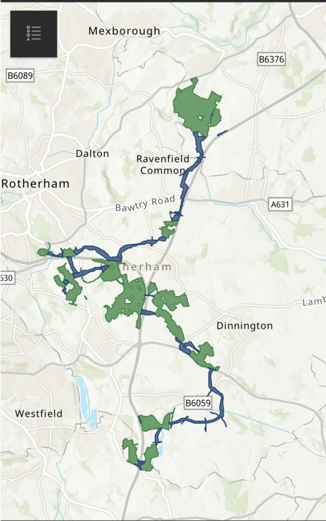
The Hidden Infrastructure: Miles of Cable Corridors
What often receives far less attention than the solar panels themselves is the infrastructure required to make these projects function.
Large solar developments require:
high-voltage export cables
underground corridors
substations and inverter stations
grid connection infrastructure
Because the final routes are often not confirmed, developers frequently submit very wide cable corridors within their applications. These corridors can stretch for miles.
The corridor is essentially a planning envelope: a wide strip of countryside within which cables may eventually be laid.
In practice, this means:
Fields, farmland, and natural landscapes can fall within a construction corridor that may extend for kilometres across the countryside.
The result is that the impact of the project stretches far beyond the solar arrays themselves.
The countryside becomes a network of infrastructure routes connecting multiple renewable developments to an already strained electricity grid.
Valleys Under Pressure
South Yorkshire’s landscape is defined by its valleys.
The Rother Valley, Don Valley and Dearne Valley have already endured generations of industrial change — coal mining, steelworks, rail infrastructure, and later brownfield regeneration.
Now they face a new transformation.
Large solar developments across the region — including proposals at Whitestone, Fenwick, Marr, Tween Bridge and Thorpe Marsh — collectively risk turning these valleys into industrial energy corridors.
Once separate schemes are viewed together, the scale becomes clear.
The countryside is no longer being considered valley by valley or community by community. Instead it is being treated as a vast hosting zone for energy infrastructure.
Solar arrays, battery storage sites, substations, cable routes and pylons all begin to converge within the same landscapes.
This cumulative impact is rarely communicated clearly to the public.
But it is the defining issue of the energy transition in rural Britain.
The Connection Problem
Perhaps the most striking feature of many large solar schemes is the uncertainty surrounding their grid connections.
Solar farms cannot operate without exporting electricity into the transmission network.
Yet the grid infrastructure needed to accommodate them is often years away from completion.
In Whitestone’s case, the proposed connection relies on infrastructure linked to the Brinsworth area near Rotherham.
But that infrastructure is itself not yet built.
In planning terms this creates a strange situation.
A solar project may be approved before the infrastructure needed to connect it actually exists.
To manage this uncertainty, developers sometimes include multiple possible connection options, substations or cable routes within the same application.
The result is what can only be described as a connection to nowhere.
The project is consented today, while the grid it depends on may not exist for many years.
A System Planning in Reverse
This reveals a deeper flaw in the way Britain’s energy system is currently being developed.
Traditionally, infrastructure planning followed a logical order:
build reliable generation
build the grid to support it
connect consumers
Today the process often appears reversed.
Generation projects are approved first.
Grid infrastructure is promised later.
And communities are expected to absorb the impact of both.
In some regions the electricity grid is already heavily constrained. Substations and transmission nodes are approaching their technical limits.
Yet new renewable projects continue to be proposed in the same locations.
The result is an ever-growing queue of schemes competing for connection capacity that may not be available for a decade or more.
The Countryside Deserves Better
None of this means Britain should not invest in energy security or modern infrastructure.
But the current approach raises serious questions.
Should vast areas of productive farmland be absorbed into projects that may not even be able to export electricity for years?
Should entire valleys be reshaped by overlapping infrastructure schemes without a clear national plan?
And should communities be asked to accept miles of cable corridors across their countryside for projects whose final grid connections remain uncertain?
These are not unreasonable questions.
They are fundamental planning questions.
The Bigger Picture
Whitestone is not an isolated proposal.
It is part of a growing pattern across Yorkshire and the Humber where solar projects are being proposed at unprecedented scale.
Individually, each project may claim to have reduced its footprint or improved its design.
Collectively, however, they represent something far larger:
A transformation of rural landscapes into energy infrastructure zones.
If Britain truly wants a secure and affordable energy future, it must begin by asking a simple question.
Are we building an energy system , or simply approving projects?
Because if the answer is the latter, we may soon find that the countryside has been sacrificed for infrastructure that was never properly planned in the first place.
Shane Oxer. Campaigner for fairer and affordable energy

Leave a comment