Excerpt:
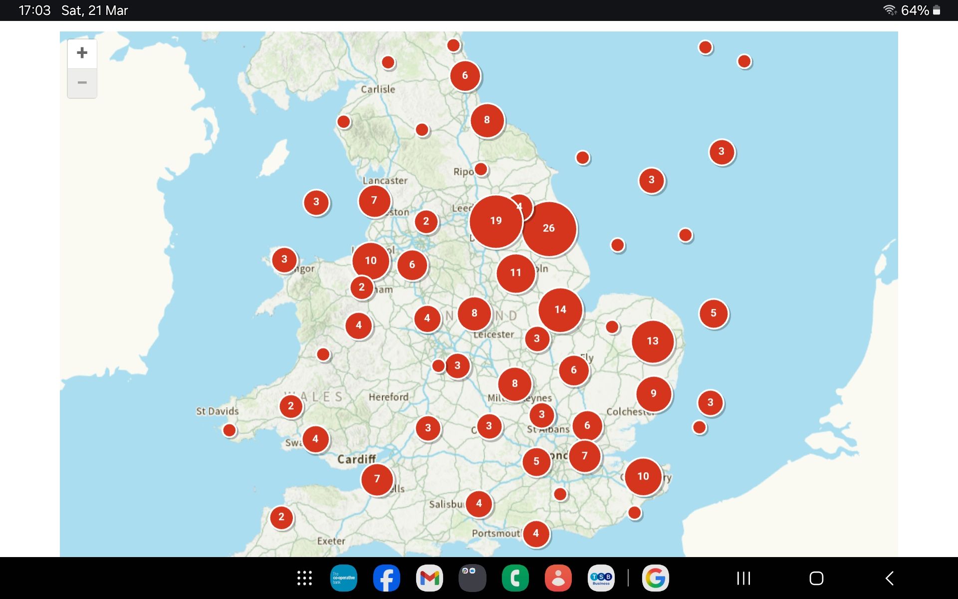
A map of Britain’s solar NSIP pipeline reveals 45 major projects amounting to almost 20GW of proposed generation. The likely land take runs into tens of thousands of hectares , and that is before counting batteries, substations, cable routes and smaller local schemes.
Britain’s countryside is being changed before our eyes.
Across England and Wales, the map is filling up with solar proposals. Red circles spread across regions. Long lists of project names are moving through the planning system. What looks at first glance like a technical database is, in reality, something much bigger:
The steady industrialisation of rural Britain through an expanding pipeline of large-scale solar schemes.
The screenshots gathered for this article show a national picture that should concern anyone who cares about food security, countryside protection, local democracy, or honest energy policy.
These are not rooftop schemes on warehouses or car parks. These are the largest solar projects in the system , schemes entering or progressing through the Nationally Significant Infrastructure Project process.
From the current list assembled, there are 45 solar NSIP projects.
Based on the published capacities attached to those schemes, the combined total comes to a working figure of 19,937.8 MW, or around 19.94 GW of solar generation.That figure is before adding battery storage, substations, cable routes, converter compounds, access roads, and the many smaller non-NSIP solar farms being pushed through local planning systems.
In other words, this is not the whole picture. It is only the top layer.A National Programme Hidden in Plain Sight
The biggest mistake in public debate is to treat these schemes as if they are isolated applications.They are not.
When viewed one at a time, each developer tells the same familiar story: clean power, temporary land use, biodiversity gain, climate responsibility.
But when the projects are viewed together on a national map, a very different reality appears. This is not piecemeal development. It is a rolling land-use transformation.
One district loses a few hundred hectares. Another gets a cable route. Another is told to host battery storage because the solar farm is already coming. Another is expected to absorb the visual impact, the traffic, the fencing, the security infrastructure, and the loss of productive agricultural land.
Each community is invited to see only its own burden. Yet cumulatively, the burden is national.
That is what the map and list expose so clearly. They show concentration, clustering and momentum. They show how the countryside is being changed not by one decision, but by accumulation.
Nearly 20GW and That Is Only the NSIP Layer
The figure of 19.94 GW is staggering on its own. It represents a huge volume of proposed or consented large-scale solar generation concentrated on land rather than roofs, brownfield sites, car parks, or already developed commercial spaces.
To make sense of that number, it helps to translate megawatts into land take.Using the commonly cited benchmark of roughly 6 acres per MW, a pipeline of 19,937.8 MW could imply a land take of about:119,627 acres , 48,417 hectares , 484 square kilometres.
That is an enormous footprint for the NSIP solar layer alone.
Even allowing for variation between schemes, the basic point does not change. This is not a modest intervention in land use. It is a major redirection of rural land into energy infrastructure on a national scale, And this is before counting the wider infrastructure that follows each project: battery sites, substations, pylons, grid upgrades, underground cables, access roads, and construction compounds.
The Public Is Not Seeing the Full Land Take
There is another reason the public should be worried: The true footprint is often larger than the headline description suggests.
Developers do not always describe land in the same way. Some figures refer to the total red-line boundary. Some refer to fenced operational area. Some refer only to panel coverage. Some exclude buffers, landscaping, cable corridors, access tracks, or grid connection works.
That makes cumulative scrutiny harder and helps obscure the real scale of countryside conversion.
The problem is worsened by the fact that NSIP schemes are only part of the overall buildout. Alongside them come: battery energy storage systems,substations,inverter compounds,cable corridors,pylons and overhead reinforcements,road alterations and construction compounds,and smaller local solar farms outside the NSIP regime.
So when people are told that one project is “temporary” or “modest,” they are often being asked to ignore the much wider infrastructure chain that follows.
The Wrong Solar in the Wrong Places
HOPE is not arguing against all solar in all forms.
The issue is the model.
Britain should have been prioritising rooftop solar, warehouse roofs, public buildings, car parks, industrial estates, and genuinely lower-conflict sites.
Instead, policy and planning have incentivised vast land-hungry schemes in open countryside, often in productive rural areas, simply because that is where developers can assemble scale.
That is not good land strategy. It is not good food strategy. And it is not honest environmentalism.
The countryside is being treated as an easy blank canvas for energy policy. It is not. It is where food is grown, habitats exist, flood patterns matter, heritage landscapes survive, and rural communities live with the consequences long after consultants and ministers have moved on.
A System Built to Fragment Opposition
One of the most frustrating parts of this process is how effectively it fragments resistance.
Each community is expected to fight one project at a time. One village is told to comment on one application. One parish is told that cumulative impacts are outside scope. One council is asked for one local impact report.
But this is not one project.
It is dozens, And once communities start joining the dots, the national pattern becomes impossible to ignore.
The map tells the truth that the process often conceals:
this is countryside-wide industrialisation by accumulation.
What HOPE Is Saying
HOPE believes the public has every right to ask basic questions that government and developers keep avoiding.
How much farmland is being committed in total?
How many communities are expected to absorb cumulative visual, ecological and infrastructure impacts?
How much of this capacity is being advanced ahead of realistic grid reinforcement?
Why is open countryside being treated as the default answer when rooftops, car parks and brownfield land remain underused?
Why are schemes assessed in isolation when their real-world effects are collective?
These are not anti-environment questions.
They are common-sense questions.
The Reality Behind the Red Circles
The screenshots behind this article are more than a map and a list. They are evidence of a policy direction.They show that this is no longer about a few isolated schemes. It is about a national planning drift that is turning rural Britain into an energy estate, one consent at a time.
From the current tally, 45 solar NSIP projects amount to roughly 19.94 GW of generation. On a commonly used planning benchmark, that could translate into around 48,417 hectares or 119,627 acres of land. And that is before counting batteries, substations, cables, roads, and smaller local projects outside the NSIP regime.That should alarm people.Because once the public sees the national picture, the central claim becomes unavoidable:
This is not a limited green transition. It is a large-scale transfer of countryside into infrastructure use, carried out incrementally enough to dull national scrutiny, but extensively enough to transform the land forever.
HOPE says enough. Britain needs a rational energy policy, not countryside sacrifice by stealth.
Shane Oxer. Campaigner for fairer and affordable energy

Leave a comment