Across England, a series of major infrastructure plans is beginning to reveal a pattern that has not yet been properly explained to the public.
On their own, the proposals appear separate and technical: a new pylon route here, a substation upgrade there, a regional growth plan somewhere else.
Each is presented as necessary, localised, and largely unavoidable. But when the pieces are placed beside one another, a larger picture begins to emerge.
Britain is not simply upgrading its electricity grid. It is beginning to organise future growth around it.
A system built for a different Britain
The existing electricity transmission network was designed for a different energy age. For decades, Britain relied on large power stations, often coal, gas or nuclear, connected to a national system that moved electricity from established generation sites to centres of demand. The geography was relatively simple: power stations, industrial areas, towns and cities were linked through a grid designed around the needs of the 20th century.
That model is now being overturned. Offshore wind, interconnectors and large-scale renewable generation are changing where electricity enters the system. More power is expected to come from coastal and northern regions, while much of the demand remains inland and further south. That means electricity must be moved over longer distances, in larger volumes, and through corridors that were never designed for this scale of flow.
National Grid’s own project material for Yorkshire GREEN states that the existing network “was not designed to transfer the current and increasing volume of generation capacity securely from the north to major centres of electricity demand in central and southern England.”¹ That sentence matters. It confirms that the grid is not being marginally adjusted. It is being redesigned to serve a new national energy geography.
The public debate often focuses on individual pylons, substations and planning applications. But the underlying issue is much bigger.
Once a country decides to generate vast amounts of electricity offshore and move it inland, it must build the infrastructure to do so. That infrastructure then becomes more than a technical necessity. It becomes a framework for future development.
Building capacity before demand arrives
The important point is that much of this grid expansion is being built for anticipated future demand and future generation, not simply for what exists today.
In the Yorkshire GREEN examination report, the need case refers to growth in offshore wind generation and interconnectors, and states that the network requires urgent reinforcement to provide capacity for these connections.² It also identifies major projects reliant on reinforcement, including offshore wind and interconnector schemes.³ The logic is clear: capacity must be created first so that future generation and future users can connect later.
That is not inherently irrational. Large infrastructure always has to be planned years in advance.
But it has profound consequences for land use. Once high-capacity electricity infrastructure is built in a particular corridor, that corridor changes.
It becomes attractive to developers, investors and energy-intensive users. Land near substations, former power stations and transmission routes becomes more valuable because it can support activities that other places cannot.
This is where the grid stops being merely a utility and starts becoming a form of spatial planning.
Where the power can go, development can follow.
Where it cannot go, growth becomes harder to justify.
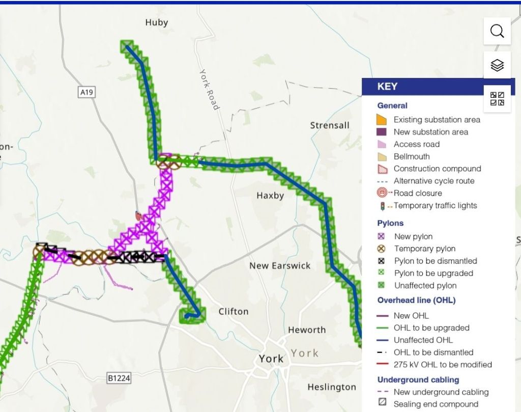
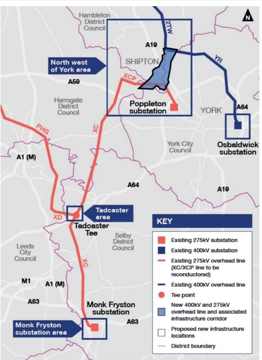
The Yorkshire GREEN route illustrates this clearly. The project involves new and upgraded infrastructure around Overton, Tadcaster, Poppleton, Osbaldwick and Monk Fryston, including new substations, overhead lines, cable sealing end compounds and realignment of existing 275kV and 400kV lines.⁴ The report also notes that much of the affected land is agricultural.⁵ In other words, rural land is being used to create a high-capacity transmission corridor that will serve future power flows and future connections.
The consequences are not limited to the land directly under pylons. Infrastructure changes the strategic value of the surrounding area. A field near a major substation is no longer just a field. A former power station site is no longer just brownfield land. A rural corridor near new 400kV capacity becomes part of a wider economic system.
Where the grid goes, growth follows
The East Midlands provides the clearest example of how this may work in practice.
A 20-year development blueprint for Derbyshire and Nottinghamshire identifies major growth concepts including a “Supercluster” around former power station sites such as High Marnham and West Burton, along with the Trent Arc and other infrastructure-led growth corridors.⁶ On its face, this looks like a regional economic plan: housing, jobs, transport, regeneration and industrial development.
But when compared with National Grid’s reinforcement plans, the alignment becomes striking. High Marnham, West Burton, Cottam, Chesterfield, Willington and associated nodes sit within the same broad geography as planned or proposed grid reinforcement. The Chesterfield to Willington scheme is proposed as a new 400kV transmission line of around 60km, linking a proposed Chesterfield substation to Willington.⁷ The wider Brinsworth to High Marnham work involves uprating existing 275kV infrastructure to 400kV and developing new substations at Brinsworth, Chesterfield and High Marnham.⁸
These are not random points on a map. They are former coal and power infrastructure locations, transmission nodes and strategic corridors. They already have, or are planned to receive, the kind of electricity infrastructure that can support large-scale industrial and energy-intensive activity.
The same model is visible in Yorkshire. Drax, Eggborough, Monk Fryston, Thorpe Marsh, Selby and the wider Doncaster corridor all sit within a geography shaped by energy infrastructure. Former power sites and substations provide the anchor points. Grid upgrades provide future capacity. Around them, proposals for energy storage, data centres, logistics and housing become more plausible.
This does not require a single secret plan. It is enough that several systems are moving in the same direction. Energy policy demands new capacity. Grid planners build the routes. Developers look for land where power is available. Local plans then accommodate housing and employment growth. The result is a pattern that may never be declared as one strategy, but functions like one.
That is why the question is no longer whether a pylon route is justified in isolation.
The question is whether the public is being shown the cumulative development model that follows from it.
The hidden geography of power
Former power station sites are central to this new geography.
They offer a combination that is difficult to replicate elsewhere: large landholdings, industrial history, grid connections, cooling potential and proximity to transmission infrastructure. In an economy increasingly dependent on electricity, these sites become immensely valuable.
A coal-fired power station that once generated electricity can become a future hub for storage, data, hydrogen, logistics or advanced industry. The towers, substations and transmission routes that once served the old energy system become the skeleton of the new one.
This is why locations such as Drax, Eggborough, Skelton Grange, West Burton, Cottam and High Marnham matter. They are not merely old industrial sites waiting to be tidied up. They are strategic power locations. They sit at the intersection of land, electricity, water, transport and planning opportunity.
Data centres make the point especially clear. They do not bring mass employment once operational, but they require enormous amounts of reliable power. Their presence near grid-rich locations is not accidental. They follow electricity. Where high-capacity supply is available or planned, data centres and other energy-intensive uses become viable. Where it is not, they struggle.
This challenges the usual language of “growth” and “jobs”. A data centre may create construction jobs and some permanent technical roles, but it is fundamentally an infrastructure asset. Its main requirement is not labour. It is power. If public policy and grid investment make rural or former industrial land suitable for that kind of use, the financial benefit may flow mainly to landowners, developers, infrastructure investors and large corporate users.
That is not necessarily unlawful or improper. But it should be openly discussed. Communities are often told that new infrastructure is needed for national progress, clean energy or economic growth. What they are less often shown is how that infrastructure can increase land values, attract private investment and trigger further development pressure around them.
A strategy without a map
The central problem is that none of this is presented as a single picture.
Grid projects are assessed as nationally significant infrastructure. Housing growth is assessed through local plans. Industrial development comes forward through private applications. Energy storage and solar projects are considered individually. Each part has its own process, its own consultation, its own technical documents and its own justification.
But land does not experience these things separately. A rural area does not feel one impact at a time. It feels the combined pressure of pylons, substations, access roads, solar schemes, battery storage, logistics parks, data centres and housing allocations.
The planning system has not caught up with that reality. It can assess the impact of one project, but it struggles to assess the pattern created by many.
That is the gap. Not that every project is unjustified. Not that all infrastructure is unnecessary. The problem is that the cumulative outcome is not being presented clearly or debated honestly.
If the grid is now shaping where growth occurs, then it is acting as a de facto spatial strategy. Yet it has not been consulted on as one.
No national map has been placed before the public showing how energy infrastructure, future industry, data demand, housing growth and land use are expected to interact over the next 20 to 30 years.
Instead, the picture emerges slowly, project by project, until the direction of travel becomes difficult to reverse.
The evidence now points to a serious question: is Britain planning communities around need, landscape, food production and local consent, or is it increasingly planning them around where electricity capacity can be created?
That question deserves a public answer.
Because Britain is not only changing how it generates electricity. It is changing where future development will happen. And if the grid comes first, then the countryside may be reshaped long before most people realise the plan exists.
Shane Oxer. Campaigner for fairer and affordable energy
Footnotes
1. Planning Inspectorate, Yorkshire Green Energy Enablement Project: Examining Authority’s Report of Findings and Conclusions and Recommendation to the Secretary of State, 14 December 2023, para. 1.3.3.
2. Ibid., paras. 1.3.3 and 3.2.8–3.2.10.
3. Ibid., paras. 1.3.18 and 3.2.11.
4. Ibid., Overview and paras. 1.3.7–1.3.13.
5. Ibid., para. 1.3.4.
6. East Midlands Combined County Authority / regional growth material on the Derbyshire–Nottinghamshire 20-year development blueprint and Supercluster proposals; accompanying public reporting on the East Midlands growth vision.
7. National Grid Electricity Transmission, Chesterfield to Willington project material, describing a proposed new 400kVi connection of approximately 60km between Chesterfield and Willington.
8. National Grid Electricity Transmission / Ofgem material on Brinsworth to High Marnham reinforcement, including uprating of existing 275kV overhead lines and new 400kV substations at Brinsworth, Chesterfield and High Marnham.

Leave a comment