Across Yorkshire, the debate over solar energy is usually presented as a series of separate local planning disputes. One village objects to one solar farm. One parish council raises concerns about one battery site. One farming family fears the loss of one block of productive land. But when the data is examined properly — using the TEC Register, the Existing Agreements register, the Transmission Works Report, and the Renewable Energy Planning Database — a much larger picture emerges.
Yorkshire is not facing scattered solar applications.
Yorkshire is being reorganised into a series of grid-led solar and battery clusters.
The visible planning applications are only the surface layer. Behind them sits a far larger grid-connection pipeline: contracted capacity, delayed connection dates, transmission reinforcement works, and a growing network of smaller sub-50 MW schemes that are harder for the public to track because they often fall below the national infrastructure threshold.
The evidence now shows that Yorkshire is carrying three overlapping solar burdens.
First, there is the visible planning pipeline recorded through the Renewable Energy Planning Database, where active Yorkshire and Humber solar schemes already total around 5,619 MW across 493 projects. Published site-area evidence already covers more than 11,000 hectares, and when missing site areas are estimated, the likely figure rises to nearly 12,000 hectares.
Second, there is the grid-connection pipeline. The TEC data for Yorkshire nodes shows approximately 15,089 MW of solar-associated capacity. This does not mean every megawatt will become a built solar farm, and it must be treated carefully because hybrid solar, wind and battery projects can overlap. But it does show the scale of connection appetite being loaded onto Yorkshire’s grid nodes.
Third, there is the Existing Agreements pipeline, which identifies roughly 9,581 MW of matched Yorkshire and Humber solar capacity after duplicate rows are removed. Of that, around 6,686 MW is post-2030, showing that a very large proportion of the solar connection queue depends on long-term grid availability rather than immediate deliverability.
Taken together, these figures show that the planning system is not giving the public a complete picture. A planning application may show one solar farm. A grid register shows the corridor behind it. A transmission works report shows the infrastructure required to make the connection possible. Only when all three are examined together does the real regional impact become visible.
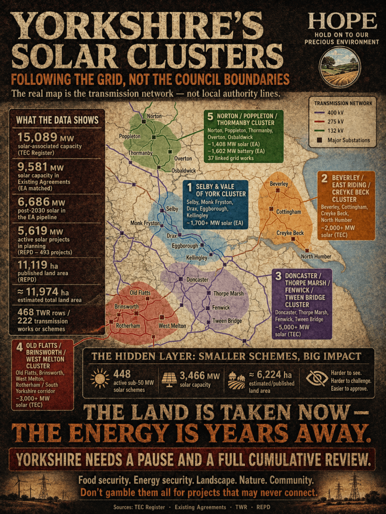
The real map is not local authority boundaries — it is grid clusters
One of the biggest mistakes in assessing Yorkshire solar development is to organise the evidence only by council boundary. That approach hides the real pattern.
Solar developers do not choose sites simply because they fall within one district or another. They follow grid access, substations, former power-station corridors, overhead line routes, and available agricultural land. This is why projects that appear separate on a planning portal are often functionally connected through the same grid node or transmission corridor.
The evidence points to several major clusters.
The first is the Selby and Vale of York cluster. This runs around Selby, Monk Fryston, Drax, Eggborough, Kellingley, Poppleton and the wider York-North corridor. This should not be treated as isolated development. It is a broad energy corridor forming across open agricultural land, with solar, battery storage, substations, pylons and reinforcement works all overlapping in the same landscape.
The second is the Beverley, East Riding and Creyke Beck cluster. This links Beverley, Cottingham, Hull’s rural hinterland, Creyke Beck and North Humber. Creyke Beck is already a critical electricity infrastructure point. The evidence shows that East Riding schemes are not just local planning cases; they are part of a wider Creyke Beck and North Humber energy hub.
The third is the Doncaster, Thorpe Marsh, Fenwick and Tween Bridge cluster. This is one of the clearest examples of cumulative impact. Fenwick, Tween Bridge, Thorpe Marsh, Brinsworth, West Melton and Old Flatts should be viewed together. They form a South Yorkshire solar and battery corridor across land that is already under pressure from grid infrastructure and former power-station connections.
The fourth is the Old Flatts, Brinsworth and West Melton cluster. This bridges Doncaster and Rotherham and shows why planning location, grid connection point and cumulative impact zone must be separated. A project may be physically located in one area, connect electrically through another, and impose landscape or infrastructure impacts across a third.
The fifth is the Norton, Poppleton, Thormanby and North Yorkshire cluster. This is especially important because it shows how the solar pipeline stretches northwards through the wider Vale of York and North Yorkshire transmission network. The Norton / Poppleton / Thormanby cluster contains around 1,408 MW of EA solar capacity, around 1,602 MW of battery capacity, and 37 linked transmission works rows in the evidence base. It includes Norton, Osbaldwick, Poppleton, Overton and Thormanby, all of which must be understood as part of the wider North Yorkshire grid-reinforcement picture.
These clusters matter because they expose the cumulative burden. Residents are often asked to judge a solar farm in isolation. But the countryside does not experience these schemes in isolation. It experiences the combined effect of panels, fencing, access roads, substations, cabling, battery compounds, construction traffic, grid reinforcements and overhead line upgrades.
Selby and the Vale of York: a corridor, not a collection of schemes
The Selby and Vale of York area is becoming one of the most important energy corridors in the region. The evidence base identifies Monk Fryston 400kV with around 1,200 MW of solar-associated capacity, Monk Fryston 275kV with around 500 MW, and Drax-related solar capacity. The wider Drax, Eggborough, Kellingley and Poppleton network is also linked to reinforcement requirements.
This matters because the Vale of York is not an industrial wasteland. It is a broad agricultural landscape with villages, open fields, heritage settings, productive farmland and long-distance rural views. When solar developers present schemes as temporary or reversible, they often understate the industrial nature of the full system. A large solar farm is not just panels. It normally involves security fencing, CCTV, inverters, access tracks, internal cabling, grid connection works and often battery storage.
When several schemes cluster around the same grid corridor, the result is not clean energy gently placed into the landscape. It is a structural conversion of countryside into energy infrastructure.
The campaign argument for Selby and the Vale of York should therefore be clear: this area is being turned into a grid-led energy belt. The issue is not whether one individual application has mitigation planting. The issue is whether the cumulative transformation of agricultural land has ever been democratically assessed as a regional policy.
Beverley, East Riding and Creyke Beck: East Yorkshire pulled into the grid machine
The East Riding and Beverley area must be treated as a Creyke Beck and North Humber cluster.
The evidence base records Creyke Beck 400kV with approximately 1,349.9 MW of solar-associated capacity, Creyke Beck GSP with around 470 MW, North Humber Connection Node A with around 600 MW, and North Humber Connection Node E with around 240 MW. This shows a clear grid-centred pattern.
Projects around Beverley, Cottingham, Hull’s rural fringe and the East Riding countryside cannot be dismissed as separate local matters. They are being drawn into the wider Creyke Beck / North Humber grid system.
This is politically and environmentally significant. East Yorkshire contains high-quality farmland, open rural landscapes and communities already affected by major energy infrastructure. The addition of large solar farms and battery projects risks compounding that burden. It also raises a serious planning question: at what point does repeated approval of individual schemes become a de facto regional land-use strategy?
The planning system is good at examining a red-line boundary. It is much weaker at examining cumulative regional change. That weakness benefits developers. It allows them to argue one project at a time, while the public experiences the combined effect.
Doncaster, Thorpe Marsh, Fenwick and Tween Bridge: the South Yorkshire solar belt
The Doncaster cluster is perhaps the most powerful example of the problem.
The evidence base identifies Thorpe Marsh 400kV with around 1,719.5 MW of solar-associated capacity, Trent Valley North Connection Node B with around 2,380 MW, Brinsworth 400kV with around 2,250 MW, and Tween Bridge 400kV with around 1,000 MW. The project examples include Fenwick Solar, Thorpe Marsh Energy Park, Thorpe Marsh Green Energy Centre, Tween Bridge Solar Park and Old Flatts Farm.
This cannot be presented honestly as a series of isolated schemes.
Fenwick and Tween Bridge sit within the same wider Doncaster and Thorpe Marsh pressure zone. Old Flatts and Brinsworth connect into the same regional story. West Melton extends that pressure towards Rotherham and the wider South Yorkshire grid corridor.
The visible planning schemes are already enormous. Tween Bridge is one of the largest solar schemes in the country. Fenwick alone is a major land-use proposal. Add Thorpe Marsh, Old Flatts, West Melton and the smaller surrounding schemes, and the picture becomes clear: Doncaster is facing a cumulative solar and battery belt.
This is not simply about energy generation. It is about land use, food production, grid capacity, construction disruption, fire and safety concerns around battery storage, landscape change, and the loss of rural character.
The correct campaign line is this:
Doncaster is not facing isolated solar applications. It is facing a connected solar and battery corridor.
Norton, Poppleton, Thormanby and North Yorkshire: the northern extension of the pipeline
The Norton / Poppleton / Thormanby cluster deserves separate attention because it shows how the pressure extends across North Yorkshire.
This cluster links Norton, Osbaldwick, Poppleton, Overton, Thormanby and the wider York-North reinforcement system. The evidence base identifies 39 EA rows in this cluster, with around 3,122 MW of total EA capacity, including approximately 1,408 MW of solar and approximately 1,602 MW of battery capacity. It also records 37 TWR-linked rows and 16 unique scheme references.
This is not a small local issue. It is a strategic transmission and connection cluster.
The significance of this area is reinforced by Yorkshire GREEN, which involves new and upgraded infrastructure around Monk Fryston, Poppleton, Overton, Osbaldwick and the Norton–Osbaldwick network. This shows that North Yorkshire’s solar pressure is being shaped not only by local planning decisions but also by major grid-reinforcement logic.
The public debate should therefore distinguish between three things: the physical location of a solar farm, the grid node through which it connects, and the wider cumulative impact zone. A solar project may appear local on paper, but its true impact may stretch across an entire corridor.
The hidden layer: 448 sub-50 MW schemes
Large solar farms attract attention because they are visible, controversial and often nationally significant. But one of the most important findings in the evidence base is the scale of the smaller schemes.
The sub-50 MW layer identifies 448 active solar schemes below 50 MW across Yorkshire and the Humber. Together, these account for around 3,465.66 MW of capacity and an estimated or published land area of around 6,224 hectares. Of those, 302 rows are flagged as land-use relevant or likely land-use relevant, accounting for around 3,402.8 MW and around 6,092 hectares.
This matters because sub-50 MW schemes can be harder to place. Many are dealt with locally. Some are rooftop or commercial installations and should not be treated in the same way as rural solar farms. But many are land-use relevant and contribute to the same cumulative pressure.
The largest sub-50 MW distributed layers include North Yorkshire, East Riding, North Lincolnshire / Humber South Bank / Keadby, West Yorkshire / Leeds-Wakefield, Norton / Poppleton / Thormanby, Selby / Vale of York, Old Flatts / Brinsworth / West Melton, and Doncaster / Thorpe Marsh / Fenwick / Tween Bridge.
This is the layer that often escapes public attention. A 49.9 MW solar farm may sound modest compared with an 800 MW NSIP. But across a region, dozens or hundreds of these schemes become a major land-use issue. They fill the gaps between the headline projects. They create a pattern of incremental countryside loss.
The public sees one proposal at a time. The registers show the accumulation.
Why the registers matter
The TEC Register, the Existing Agreements register, the TWR and the REPD each show a different part of the problem.
The TEC Register shows contracted or queued capacity. It is not a planning register, but it reveals the scale of demand being placed on grid nodes.
The Existing Agreements register helps identify connection dates and the timing problem. When large amounts of capacity are pushed into the 2030s, the public should ask whether schemes are being promoted before the grid can realistically accommodate them.
The TWR identifies the enabling works and wider reinforcements. This is crucial because solar schemes are often presented as if they simply plug into the grid. In reality, many depend on wider network upgrades, circuit-breaker replacements, reconductoring, bay extensions, new substations, power-flow control devices and other infrastructure.
The REPD gives the strongest planning and land-use evidence. It identifies projects, locations, authorities, development status and, where available, published site areas.
No single register tells the whole story. But when combined, they reveal a pattern that local planning committees rarely see in full.
The land-use problem
Supporters of large-scale solar often argue that solar uses only a small percentage of national land. That argument is misleading when applied locally.
Land-use impact is not experienced nationally. It is experienced by specific communities, in specific landscapes, around specific grid nodes.
If several thousand hectares are concentrated around Selby, Doncaster, Beverley, Creyke Beck, Thormanby or the Vale of York, the local impact is severe even if the national percentage appears small. The countryside is not an abstract percentage. It is made up of farms, villages, footpaths, views, drainage systems, hedgerows, wildlife corridors and food-producing soil.
Solar developers frequently describe land as low-grade, temporary or reversible. But a 40-year solar lease can remove land from food production for a generation. The infrastructure may be technically removable, but the landscape, soil structure, drainage patterns and rural character can be permanently altered.
The issue is not whether Britain should have any solar power. The issue is whether Yorkshire’s farmland should be treated as the default location for industrial-scale energy infrastructure when there are alternatives: rooftops, brownfield land, car parks, commercial buildings, public-sector estates, rail corridors, and domestic energy efficiency.
The democratic problem
The public has not been asked whether Yorkshire should become a major solar and battery corridor.
Instead, the transformation is happening through fragmented decisions. One planning authority considers one scheme. The Planning Inspectorate examines one NSIP. Grid bodies process connection requests. Transmission operators plan reinforcements. Developers submit applications. Each process claims to be technical, limited and procedural.
But the combined effect is strategic.
That is the democratic gap.
If Yorkshire is being reorganised around solar, BESS and transmission infrastructure, then the public deserves a regional debate. It should not be left to parish councils, local objectors and individual residents to piece together the evidence from separate registers.
The burden of proof should be reversed. Developers and government should have to show that the cumulative impact is acceptable, that food-producing land is not being unnecessarily sacrificed, that grid capacity is genuinely deliverable, that alternatives have been properly assessed, and that local communities are not being overwhelmed by sequential applications.
Conclusion: Yorkshire needs a pause and a full cumulative review
The evidence now supports one central conclusion.
Yorkshire is not facing a normal planning pipeline. It is facing a grid-led transformation of its countryside.
The visible planning pipeline already represents thousands of hectares. The TEC and EA registers reveal a much larger connection pipeline behind it. The TWR shows that many projects depend on major grid reinforcement. The sub-50 MW layer shows that smaller schemes are spreading the pressure further across North Yorkshire, South Yorkshire, East Riding, West Yorkshire and the Humber.
This is not planning by consent. It is planning by accumulation.
Yorkshire needs a full cumulative solar and battery review before more farmland is committed. That review should map every major and minor scheme, identify its grid connection, calculate land take, assess food-production loss, examine drainage and flood risk, account for BESS safety, and test whether grid reinforcements are actually deliverable.
Until that work is done, approving more schemes would be irresponsible.
The campaign message is simple:
Yorkshire is not being asked to host a few solar farms. It is being divided into solar and battery clusters around the grid — Selby and the Vale of York, Beverley and Creyke Beck, Doncaster and Thorpe Marsh, Old Flatts and Brinsworth, and Norton / Poppleton / Thormanby across North Yorkshire.
That is a regional land-use transformation.
And the people of Yorkshire deserve to know the true scale before it is too late.
Shane Oxer — Campaigner for fairer and affordable energy

Leave a comment